Cyclone Akvan Projected to Make Landfall Along Andhra Coast on November 20
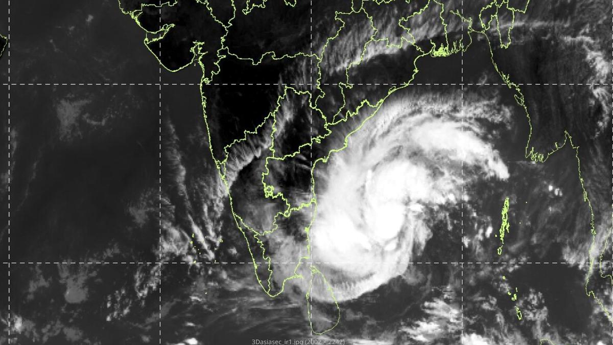
Cyclone Akvan is forecast to make landfall along the Andhra Pradesh coast between Nellore and Tuni around noon on November 20, bringing sustained winds of up to 130 kmph and heavy coastal downpours.
In this piece
The India Meteorological Department has projected that Cyclone Akvan will cross the Andhra Pradesh coastline between Nellore and Tuni by noon on November 20.…
Cyclone Akvan is projected to cross the Andhra Pradesh coast between Nellore and Tuni around noon on November 20, according to forecasts issued by the India Meteorological Department. The developing weather system over the Bay of Bengal is expected to maintain significant strength as it tracks northwestward toward the Indian mainland. Coastal districts across the state have been placed on heightened watch as meteorologists monitor the evolving atmospheric disturbance.
Meteorological authorities reported that the system originated from a depression that is steadily organizing over favorable oceanic conditions. Forecasters predict the disturbance will escalate into a cyclonic storm and subsequently intensify into a severe cyclonic storm over the central Bay of Bengal. Atmospheric parameters, including sea surface temperatures and low vertical wind shear, are expected to support this progressive intensification over the coming days.
At the time of landfall, Cyclone Akvan is expected to carry maximum sustained surface wind speeds ranging between 120 and 130 kilometers per hour, with gusts reaching up to 145 kilometers per hour. Such destructive wind velocities classify the approaching storm as a very severe cyclonic storm. Weather officials caution that winds of this magnitude pose serious hazards to thatched structures, power transmission poles, and mature trees along the landfall corridor.
The weather agency warned that the storm will generate rough to very rough sea conditions along the south and central Andhra Pradesh coastline, extending toward the adjoining Yanam region. Fishermen have been strictly advised against venturing into deep waters until the system passes and marine conditions subside. Coastal shipping operations, small watercraft, and port authorities have also been urged to take necessary precautionary measures ahead of the storm's approach.
Alongside severe gale-force winds, the cyclone is forecast to unleash widespread precipitation across coastal Andhra Pradesh, with isolated localities facing heavy to extremely heavy rainfall. The storm's expansive outer rainbands are also projected to bring cloudy skies and intermittent downpours to neighboring coastal areas in Odisha, northern Tamil Nadu, and parts of Telangana. Rainfall activity is expected to gradually intensify over coastal regions as the central vortex approaches the shoreline.
The stretch of coastline between Nellore and Tuni encompasses extensive agricultural belts, aquaculture facilities, and densely populated delta settlements that remain vulnerable to storm surges and drainage congestion. Post-monsoon cyclones in the Bay of Bengal during October and November frequently test coastal infrastructure due to the region's geographical alignment and low elevation. Historically, storms taking similar northwestward tracks have brought substantial localized flooding to low-lying coastal basins.
State and district administrative bodies have begun reviewing preparedness measures in coordination with disaster management guidelines following the IMD alert. Officials are monitoring river levels, reservoir capacities, and coastal embankments to plan for potential evacuations and relief operations if required. Emergency response teams and civic personnel are being instructed to remain on standby to clear transport routes and restore essential utilities in the event of disruptions.
The timing of Cyclone Akvan also raises significant concerns for regional agricultural communities, as standing kharif crops and harvested produce remain vulnerable to severe weather. Unseasonal torrential rains and gale-force winds threaten to lodge standing paddy and damage horticulture plantations across coastal districts. Local administrations routinely advise farmers in the cyclone's projected path to expedite harvesting where feasible and secure grain stocks in elevated storage facilities.
The India Meteorological Department emphasized that tracking models will continue to be updated as new data becomes available from coastal Doppler radars and meteorological satellites. Forecasters noted that precise landfall coordinates and timing could undergo minor adjustments depending on ambient steering currents over the Bay of Bengal. Residents throughout coastal Andhra Pradesh have been urged to avoid panic, closely follow verified official advisories, and prepare for turbulent weather conditions through November 20.
Primary source: Google News Andhra Pradesh. Newzly rewrites and structures source reporting for clarity; verify critical details at the original.