Subtropical Storm Threat Looms in Atlantic, Bringing Heavy Rain and Wind to North Carolina Coast
A developing low-pressure system off the Southeast coast could organize into a subtropical storm, threatening North Carolina beaches with heavy rain, high winds, and coastal flooding.
In this piece
Forecasters are monitoring a developing low-pressure system in the Atlantic that could become a subtropical storm over the coming days. The system is expected…
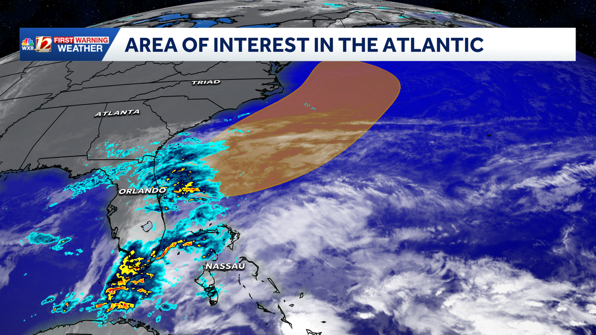
A developing low-pressure system off the southeastern United States coastline could soon organize into a subtropical storm, threatening North Carolina beaches with powerful wind gusts, heavy rainfall, and rough surf. Meteorologists are closely monitoring the Atlantic disturbance as environmental conditions become increasingly favorable for organization over the coming days. Coastal communities from the Outer Banks southward are already preparing for deteriorating weather conditions ahead of the weekend.
Forecasters with the National Hurricane Center have identified the non-tropical low interacting with warm ocean currents along the Gulf Stream. The system is feeding on these warmer waters while colliding with an upper-level disturbance moving through the atmosphere. Meteorologists note that the weather pattern holds a moderate probability of formal subtropical or tropical development as it spins off the coast.
Weather specialists emphasize that coastal North Carolina will experience significant impacts regardless of whether the system officially receives a subtropical classification or name. Heavy surf, strong gale-force gusts, and localized flash flooding pose immediate risks to shoreline settlements and low-lying barrier islands. Emergency personnel stress that storm impacts frequently extend far beyond the formal center of developing subtropical systems.
Sustained onshore winds are expected to drive bands of torrential rain across coastal counties, increasing the potential for localized urban and roadway inundation. Low-lying stretches along coastal routes and coastal highways are particularly vulnerable to standing water and washouts during the heaviest downpours. Forecasters advise drivers to remain alert and avoid navigating through water-covered roadways throughout the duration of the storm.
Dangerous marine conditions represent one of the primary threats associated with the approaching weather system. The combination of strong offshore winds and large ocean swells will create treacherous breaking surf and life-threatening rip currents along beaches. Maritime authorities and local ocean safety agencies urge swimmers and small craft operators to stay out of the water until seas subside.
Persistent northeast winds driving water against the shoreline will also trigger tidal flooding during periods of high tide. Several low-lying coastal neighborhoods could see minor to moderate soundside and oceanfront inundation as seawater backs up into tidal creeks. In addition, consecutive cycles of rough wave action threaten to cause noticeable beach erosion along vulnerable dune lines.
Subtropical systems differ from typical tropical cyclones because they feature a hybrid thermodynamic structure and broader overall wind fields. Instead of concentrating their most severe weather around a tightly wound core, subtropical lows distribute intense winds and squalls across hundreds of miles. This wide footprint means communities well removed from the storm's track can still experience substantial impacts.
Across coastal North Carolina, public works crews and emergency management offices have begun clearing storm drains and securing exposed municipal equipment. Residents and business owners are being advised to fasten patio furniture, clear outdoor debris, and check emergency preparedness kits. Utility providers are also placing crews on standby to respond swiftly to any wind-related electrical outages.
The unfolding situation highlights the hazards posed by transitional coastal storms that frequently affect the Atlantic seaboard during seasonal weather shifts. Neighboring coastal areas in the Mid-Atlantic and southeastern regions are keeping a close watch on radar trends and steering patterns. Even modest offshore systems can rapidly disrupt transit, commercial fishing, and local tourism along coastal corridors.
Meteorologists will continue to track the storm's trajectory as mainland steering currents dictate whether the low drifts closer to shore or bends outward into the North Atlantic. Updated advisories from the National Hurricane Center and local National Weather Service offices will provide critical clarity on timing and wind thresholds. Coastal residents are advised to monitor official forecast channels closely as the system progresses.
Primary source: Google News North Carolina. Newzly rewrites and structures source reporting for clarity; verify critical details at the original.