Northeast Florida Faces Tidal Flooding Risks as Rain Tapers Off
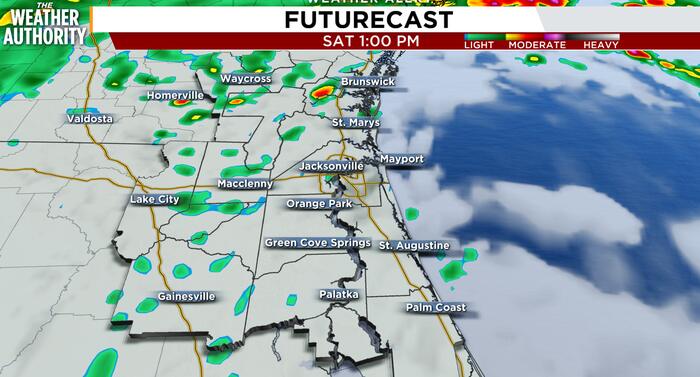
Northeast Florida faces ongoing tidal flooding hazards across coastal and riverfront areas this Saturday, even as lingering morning rainfall is forecast to taper off by the afternoon hours.
In this piece
Tidal flooding risks continue to impact low-lying and coastal communities across Northeast Florida this Saturday. While radar indicates that morning rainfall…
Residents across Northeast Florida faced persistent coastal and tidal flooding threats on Saturday as regional waterways swelled and intermittent precipitation swept across the area. Local meteorologists reported that while the heaviest rain bands were projected to taper off by Saturday afternoon, tidal flooding risks would remain elevated along vulnerable shorelines. Forecasters urged community members to remain vigilant through the day's high tide cycles.
Radar tracking showed lingering bands of showers moving through coastal and inland corridors during the morning hours. Although the rainfall intensity began diminishing heading into the midday period, saturated soils and elevated water tables left little capacity for rapid drainage. Atmospheric conditions indicated a transition toward drier air later in the day, providing an eventual break from active downpours.
The primary hazard during this weather event stems from swollen tidal channels and persistent water retention rather than prolonged rainfall alone. Low-lying zones along the Atlantic coast, the Intracoastal Waterway, and adjacent river basins typically experience saltwater push during critical lunar and wind alignments. When elevated tides coincide with freshwater runoff from earlier storms, local waterways frequently back up into neighborhood streets and coastal access roads.
The St. Johns River system represents a particular area of concern during extended coastal weather events across Northeast Florida. Because the river flows northward with a very gentle gradient, trapped water often drains slowly, prolonging flooding conditions well after active precipitation departs. Estuarine areas and tributary creeks branching off the main river channel remain susceptible to localized overflow during peak tidal windows.
Local officials and transportation departments routinely caution motorists about hazards associated with inundated low-lying thoroughfares. Standing water can conceal washed-out pavement, obscure submerged debris, and disable vehicle engines even in seemingly shallow conditions. Commuters and coastal residents are advised to obey posted barricades and avoid driving through flooded intersections.
Property owners in flood-prone districts have had to manage potential water encroachment around docks, yards, and ground-level structures. Marine operators and waterfront business owners frequently monitor mooring lines and dock heights as water levels fluctuate near flood stage. Communities accustomed to high-water occurrences have implemented routine precautions, including moving vulnerable equipment to higher ground.
Meteorological guidance highlights that the timing of daily high tides remains the decisive factor for when flooding hazards peak. Water levels that appear manageable during low tide can surge quickly as the incoming tide pushes seawater back into coastal estuaries. Even as skies clear overhead, the residual coastal surge can maintain hazardous conditions across low-lying terrain for several hours following high tide.
The gradual tapering of rain showers across the afternoon offers a welcome improvement in general atmospheric conditions across the region. With cloud cover expected to thin and precipitation chances falling, ground surfaces will begin the initial stages of drying out. However, meteorologists emphasize that the cessation of rainfall does not immediately resolve the tidal overflow along the coast.
Forecasters and weather monitoring services will continue tracking water level sensors and coastal gauge networks throughout the weekend. Residents are advised to stay tuned to updated bulletins from local weather authorities and emergency management agencies for real-time advisories. As tidal cycles gradually stabilize over the coming days, water levels across Northeast Florida are expected to slowly recede back toward normal thresholds.
Primary source: Google News Florida. Newzly rewrites and structures source reporting for clarity; verify critical details at the original.