Timeline: New Significant Flooding Threatens Central Florida as Heavy Rains Return
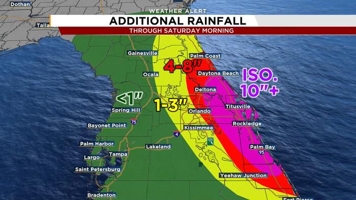
Meteorologists warn that Central Florida faces significant new flood risks as heavy downpours threaten already saturated ground and swollen waterways, with the heaviest rainfall projected east of Orlando.
In this piece
Central Florida communities are preparing for renewed flooding as incoming rain bands threaten to overwhelm saturated soil and swollen rivers. Forecasters…
Central Florida communities are facing renewed risks of significant flooding as another round of intense rainfall moves across the region. Weather forecasters with WKMG News 6 indicate that the incoming weather pattern will likely exacerbate standing water and push vulnerable waterways higher. The most severe threats are concentrated in communities east of the Orlando metropolitan corridor.
Meteorological models project widespread accumulations that could deliver several inches of precipitation across already saturated ground within a condensed time window. Localized pockets could experience significantly higher totals if training downpours repeatedly track over the same neighborhoods. The forecast timeline indicates that the heaviest bands are expected to produce rapid runoff and immediate drainage challenges.
The primary concern for regional forecasters stems from the lack of capacity in the soil following recent periods of sustained wet weather. With ground conditions thoroughly waterlogged, even moderate rain rates cannot easily absorb into the earth, transforming typical stormwater into immediate surface runoff. Low-lying intersections, residential subdivisions, and roadways with standard drainage systems are therefore especially vulnerable to rapid inundation.
Major drainage arteries across east-central Florida, including the St. Johns River basin, have already been contending with elevated levels and major flood stages. Additional runoff flowing from surrounding tributaries and urban centers threatens to prolong high-water conditions along the riverbanks. Hydrologists monitor these levels closely, as river flooding often lingers well after active precipitation clears the area.
The highest probability of severe impacts remains focused across coastal and eastern inland sections, stretching toward the Atlantic coastline. Counties east of Orlando, including Brevard, Volusia, and Seminole, have repeatedly been highlighted by weather models as prime corridors for enhanced moisture convergence. In these areas, proximity to coastal drainage obstacles and swollen lakes compounds the flood danger.
Transportation officials and emergency managers emphasize that persistent ponding creates hazardous travel conditions across major regional arteries and neighborhood streets. Water covering roadways obscures depth and underlying structural damage, significantly increasing the likelihood of stranded vehicles. Commuters and delivery fleets have been advised to exercise caution and avoid driving through submerged roads.
Municipalities throughout the impacted corridor have activated monitoring protocols to clear storm drains and position emergency pumps in flood-prone subdivisions. Residents in historically vulnerable neighborhoods have been encouraged to inspect property drainage, secure loose outdoor items, and prepare for potential access disruptions. Local public works crews remain on standby to respond to reports of rising neighborhood waters.
Forecasters point to a slow-moving atmospheric setup drawing deep tropical moisture northward over the Florida peninsula as the catalyst for the sustained precipitation. When atmospheric moisture values remain exceptionally high, individual storm cells become highly efficient rainmakers capable of producing intense rainfall rates in short intervals. This dynamic creates immediate flash flood conditions regardless of standard municipal drainage capacity.
Repeated flooding events place an escalating burden on local infrastructure, residential property, and emergency response resources across Central Florida. With water tables remaining at historic highs, consecutive storm systems allow little time for natural dissipation or structural recovery between rain episodes. For property owners along lakes and rivers, every additional inch of rain threatens to breach thresholds that were only recently restored.
Looking ahead, meteorologists expect flood watches and localized advisories to remain in effect until the primary rain-producing system shifts away from the state. Weather observers continue to track the exact progression of coastal bands to pinpoint where the heaviest deltas will settle through the end of the week. Officials maintain that conditions will require continued vigilance from residents until river stages begin a definitive downward trend.
Primary source: Google News Florida. Newzly rewrites and structures source reporting for clarity; verify critical details at the original.