Last Ice on Indonesia's Puncak Jaya Has Shrunk to Scattered Patches, NASA Reports
The remaining tropical ice fields atop Indonesia’s Puncak Jaya have deteriorated into isolated, static patches. Satellite observations confirm the remnants are now too small to flow like active glaciers, signaling the imminent loss of Southeast Asia's last equatorial ice.
In this piece
Glacial ice near the summit of Indonesia's Puncak Jaya has diminished into fragmented patches that can no longer sustain active glacial flow, according to NASA…
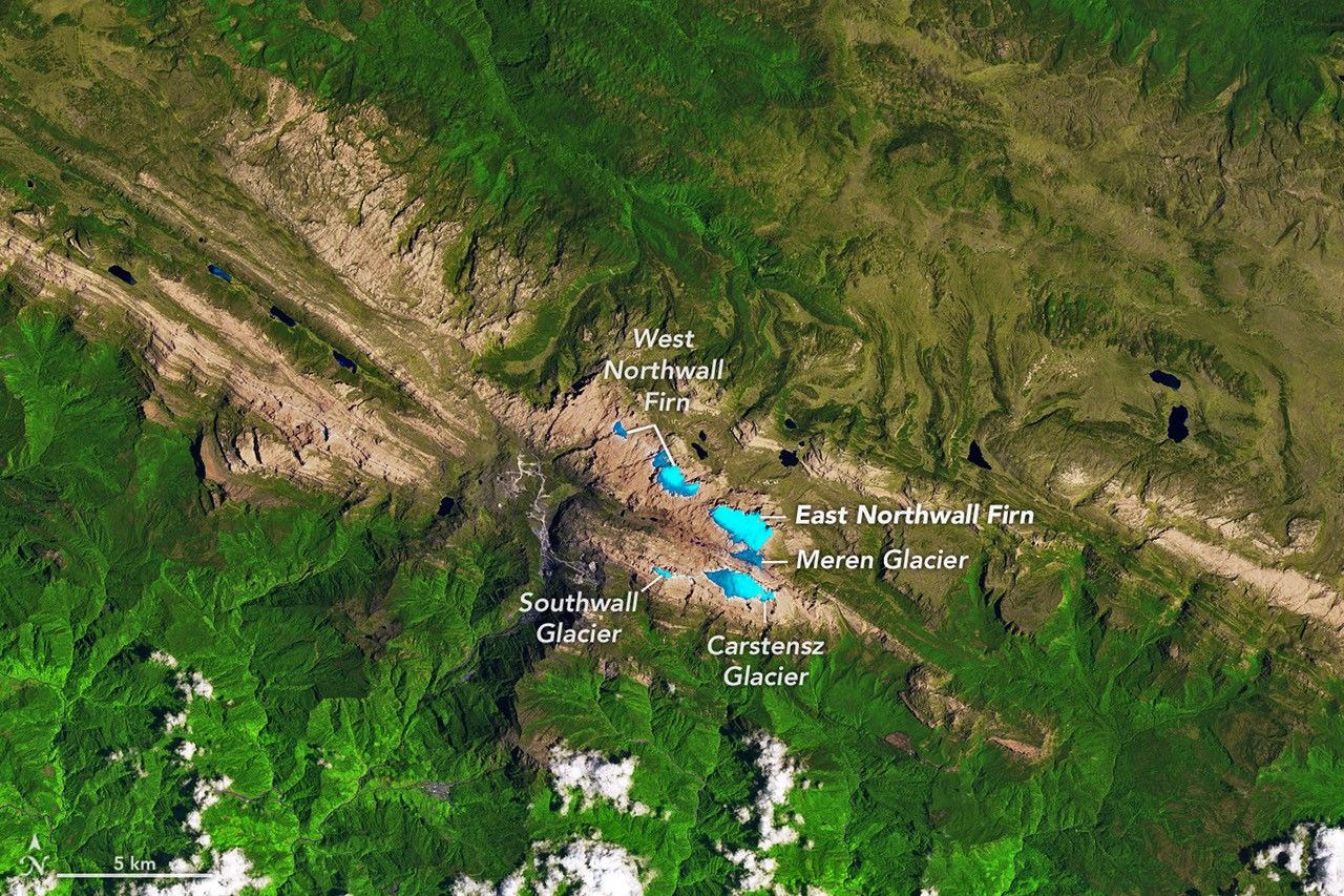
Glacial ice near the summit of Puncak Jaya in Indonesia has deteriorated into scattered remnants that are now too small to maintain the internal flow of active glaciers, according to satellite observations highlighted by NASA. The latest imagery shows that the ice fields capping the high-altitude peak have fragmented into isolated patches across the rugged crest, confirming a relentless retreat that scientists have tracked over decades.
The transition from dynamic glaciers to stagnant ice patches signifies a terminal phase for the mountain's frozen mantle. To be classified and function as a glacier, an ice mass must possess sufficient thickness and mass to deform under its own weight and gradually flow downhill. Without that threshold of volume, the remaining high-elevation remnants on Puncak Jaya behave simply as stationary snow and ice fields vulnerable to rapid surface melt.
Puncak Jaya, situated in the Sudirman Range of Indonesia's Papua province, has long stood out as an anomaly of physical geography. Reaching an elevation of nearly five thousand meters above sea level, the peak historically preserved one of the few tropical ice complexes anywhere in the western Pacific warm pool. Its glaciers existed under rare equatorial conditions where persistent atmospheric moisture combined with severe high-altitude chill to generate perennial ice masses.
Scientific records and satellite missions dating back to the late twentieth century document that the summit area once hosted substantial glaciers, including the now-vanished Meren and Southwall ice fields. Decades of atmospheric warming across the tropics, punctuated by powerful El Niño weather patterns, steadily overwhelmed the high-altitude snow accumulation needed to replenish the ice. As melting consistently outpaced new winter snowfall, the contiguous ice bodies progressively thinned, detached from one another, and receded into rocky depressions.
The loss of glacial vitality on Puncak Jaya mirrors a broader crisis confronting the world's rare equatorial glaciers. Tropical ice masses in South America's northern Andes and on the volcanic summits of East Africa have suffered similar rates of precipitous shrinkage over recent generations. Because tropical glaciers occupy narrow climate niches near the freezing threshold, even minor shifts in regional temperature and moisture circulation dramatically alter their mass balance.
Glaciologists consider tropical glaciers crucial indicators of environmental change, often describing them as natural barometers for the mid-troposphere. While lowland instruments measure surface heating, high-altitude glaciers capture broader thermal shifts in the upper atmosphere across the equatorial belt. The rapid reduction of Puncak Jaya’s ice to tiny, immobile fragments provides physical evidence of warming atmospheric layers that are difficult to observe from ground stations alone.
Beyond their scientific importance as atmospheric markers, the vanishing ice deposits also hold distinct cultural and regional significance in Papua. While the summit glaciers are too small to supply major downstream irrigation systems, their historical presence has shaped local indigenous landscapes and regional identity. Their dissolution leaves behind barren limestone ridges and altered microclimates on the highest summits of the island.
Monitoring the summit ice has posed formidable logistical hurdles for researchers over the years due to persistent cloud cover, remote terrain, and steep topographical gradients. Earth-observing satellites equipped with multi-spectral sensors have therefore served as essential monitoring tools, enabling scientists to evaluate surface area changes through cloud breaks. The remote sensing data has consistently recorded the step-by-step disintegration of the ice into the stagnant patches seen today.
With the remaining ice fields now fragmented into small pockets, glaciologists and Earth-monitoring agencies anticipate that the ice could disappear entirely within the coming years if current climatic trends persist. Without active glacial movement to replenish lower sectors, solar radiation and rain-driven melting will continue to erode the exposed remnants from all edges. NASA and affiliated monitoring networks are expected to continue tracking the final stages of Puncak Jaya's ice, documenting a historic transformation of one of the planet's rarest tropical landscapes.
Primary source: NASA Breaking News. Newzly rewrites and structures source reporting for clarity; verify critical details at the original.