NASA Warns 2026 El Niño Could Surpass Historic 1997 Event
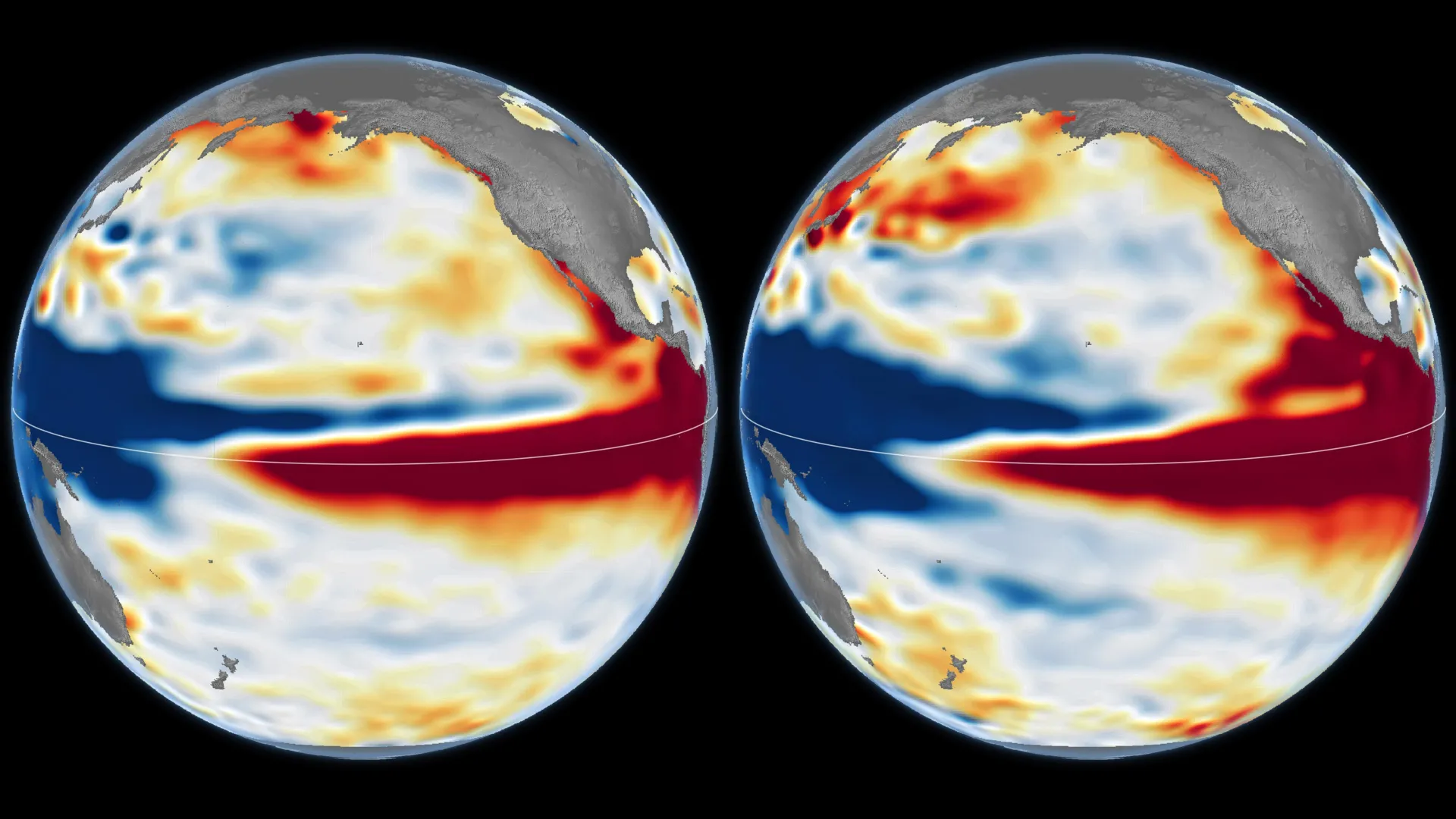
NASA satellite data indicate that the rapidly intensifying 2026 El Niño could exceed the legendary 1997-1998 event, raising concerns over severe rainfall, widespread flooding, and global weather disruptions this winter.
In this piece
Satellite observations show the developing 2026 El Niño mirrors the historic 1997-1998 pattern, raising the prospect of extreme rainfall and severe flooding…
NASA scientists are warning that the rapidly intensifying 2026 El Niño climate pattern could rival or even surpass the historic 1997-1998 event. Satellite observations tracking ocean conditions across the tropical Pacific reveal striking physical similarities between the two atmospheric systems, pointing toward potentially severe weather disruptions across the globe in the months ahead.
Data gathered by orbiting satellites indicate an extensive buildup of warm surface waters along the equatorial Pacific Ocean. These high ocean temperatures, which characterize strong El Niño episodes, represent an immense reservoir of thermal energy capable of altering global atmospheric circulation. Researchers tracking the development note that the current rate of ocean warming mirrors conditions that preceded one of the most powerful climate events on record.
The benchmark 1997-1998 El Niño remains one of the strongest and most disruptive climate phenomena observed in modern meteorological history. During that cycle, torrential rains, widespread flooding, and destructive storms battered parts of North and South America, while severe droughts and devastating wildfires afflicted southeast Asia and Australia. Global weather extremes triggered by that system resulted in billions of dollars in economic damages and widespread ecological disruptions.
El Niño develops when prevailing trade winds weaken across the equatorial Pacific, allowing warm water from the western ocean to shift eastward toward the Americas. This eastward shift in ocean heat dramatically repositions atmospheric convection, disrupting the jet streams that guide weather patterns across mid-latitude continents. When ocean surface anomalies reach extreme thresholds, the resulting atmospheric feedback loops can intensify seasonal storm tracks and alter regular precipitation patterns worldwide.
If the current trajectory continues into the Northern Hemisphere winter, forecasters anticipate a substantial elevation in the likelihood of major rainfall and severe flooding events. Atmospheric shifts associated with powerful El Niño episodes frequently channel moist subtropical air toward coastal regions and desert basins that rarely experience sustained heavy downpours. Conversely, other regions around the globe may face diminished monsoon rains, uncharacteristic dry spells, and heightened wildfire dangers.
Despite the dramatic satellite parallels with the late 1990s, scientists emphasize that the precise impacts of any individual climate event cannot be predicted with total certainty. Atmospheric conditions do not always respond identically to ocean warming, as background global climate conditions, regional sea temperatures, and secondary pressure systems can modulate local storm behavior. Forecasters caution that while satellite indicators establish the potential for extreme outcomes, local meteorological manifestations will depend on dynamic factors evolving over the coming weeks.
The prospect of a record-setting climate event carries profound implications for emergency managers, agricultural sectors, and municipal water authorities. Preparedness measures often require months of advance planning to protect vulnerable infrastructure from catastrophic stormwater runoff, mudslides, and coastal surges. At the same time, regional water managers must balance flood containment strategies against long-term water storage needs in anticipation of potential drought shifts once the cycle subsides.
Meteorologists and oceanographers worldwide will continue to monitor satellite telemetry and ocean buoy arrays closely as the system approaches its typical winter peak. Research teams are refining numerical climate models to narrow regional forecast ranges and provide updated impact assessments to public safety organizations. For now, scientists stress that communities across potentially affected zones should remain vigilant as observations determine whether this emerging event truly eclipses its legendary predecessor.
Primary source: ScienceDaily. Newzly rewrites and structures source reporting for clarity; verify critical details at the original.