NASA Altimetry Data Compares Current El Niño to Historic Events
Using a 35-year satellite altimetry record, scientists are measuring the footprint of current El Niño conditions against the strongest historical events in modern observation history.
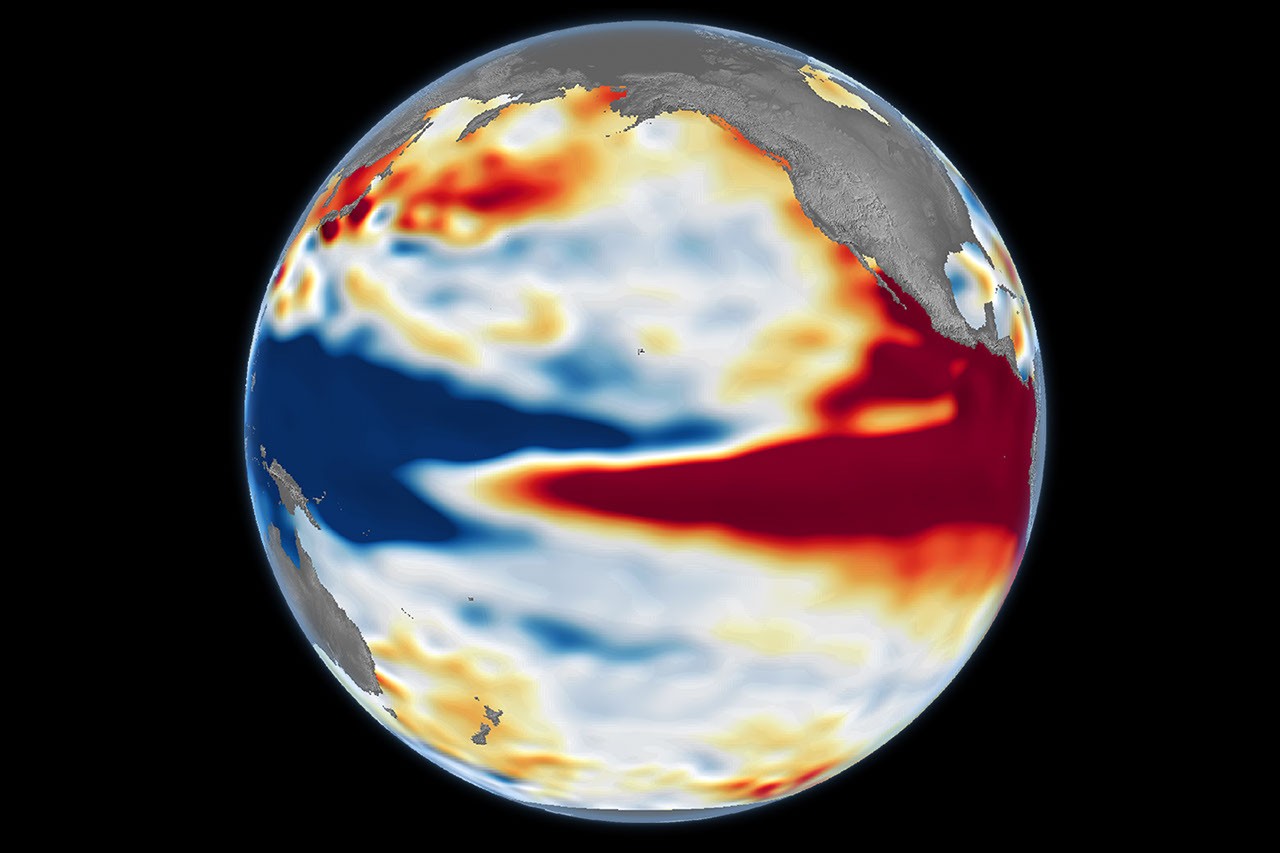
Scientists tracking global ocean conditions are utilizing an unbroken 35-year satellite record to evaluate the current El Niño against the strongest events in modern history. High-precision altimetry datasets managed by NASA allow researchers to benchmark ongoing equatorial Pacific conditions against previous climate milestones. The multi-decade archive provides researchers with unprecedented perspective on how modern ocean dynamics compare to past historical extremes.
The space-based measurements rely on radar altimeters deployed on missions such as Sentinel-6 Michael Freilich, building on foundations laid by TOPEX/Poseidon and the Jason series. Because seawater expands as its temperature climbs, elevated sea surface heights serve as a clear signature of accumulated heat content in the upper ocean. Altimeters capture these subtle ocean surface variations from orbit with millimeter-scale accuracy across thousands of miles of open sea.
Recent side-by-side visualizations reveal that the spatial signature of current anomalies bears a striking resemblance to the powerful 1997–1998 event. Extensive bands of higher-than-average sea levels stretch eastward across the central and eastern Pacific basin. These widespread height anomalies indicate that an immense volume of tropical warmth has gathered along the equatorial corridor.
Scientists have also contrasted the current profile with the strong El Niño of 2015–2016, which displayed notable regional variations. During that earlier event, the core of warmest water remained centered farther offshore rather than pressing directly against the South American coastline. Such structural differences are critical because subtle shifts in heat distribution can significantly alter atmospheric responses.
Tracking these sea height variations allows oceanographers to monitor equatorial Kelvin waves moving beneath the surface. These massive pulses of warm water travel slowly toward the Americas when prevailing trade winds weaken or collapse. As they propagate across the basin, they cap the usual upwelling of colder, nutrient-dense water along the equator and reorganize local marine environments.
The continuous 35-year observational timeline represents a major leap forward for climate science and long-term ocean monitoring. Before satellite altimetry became routine in the early 1990s, scientists were forced to piece together ocean conditions from scattered buoys, coastal tide gauges, and passing merchant ships. Spaceborne sensors now capture the entirety of the tropical Pacific simultaneously, preserving a uniform and objective historical record.
Understanding the precise scale of an El Niño is vital because these massive ocean heat anomalies exert a profound influence on global weather patterns. The reallocation of thermal energy across the tropical ocean alters atmospheric pressure cells and shifts the trajectory of planetary jet streams. These jet stream perturbations often trigger abnormal precipitation cycles, severe droughts, and altered storm tracks across multiple continents.
Researchers caution, however, that even close historical resemblances do not provide a guaranteed blueprint for seasonal weather behavior. While altimetry maps show patterns reminiscent of past heavyweight events, every El Niño develops within an inherently chaotic climate system. Local meteorological conditions, atmospheric moisture, and existing weather regimes can produce unexpected departures from historical precedent.
Satellites will maintain continuous surveillance over the Pacific over the coming months to record how the ocean anomalies evolve. Forecasters and oceanographers plan to track the eventual decay and cooling of these elevated waters to gauge how atmospheric teleconnections might transition. As the season progresses, the 35-year archive will remain an essential tool for evaluating how contemporary climate shifts align with the past.
Primary source: NASA Breaking News. Newzly rewrites and structures source reporting for clarity; verify critical details at the original.