Early-Season Snowstorm Blankets California’s Sierra Nevada in White
A widespread mid-November snowstorm coated California’s Sierra Nevada mountains in white, providing an early boost to alpine terrain as meteorologists and water managers track the start of the winter season.
In this piece
A broad mid-November storm delivered an early blanket of snow across California’s Sierra Nevada mountains, marking the arrival of winter conditions. Satellite…
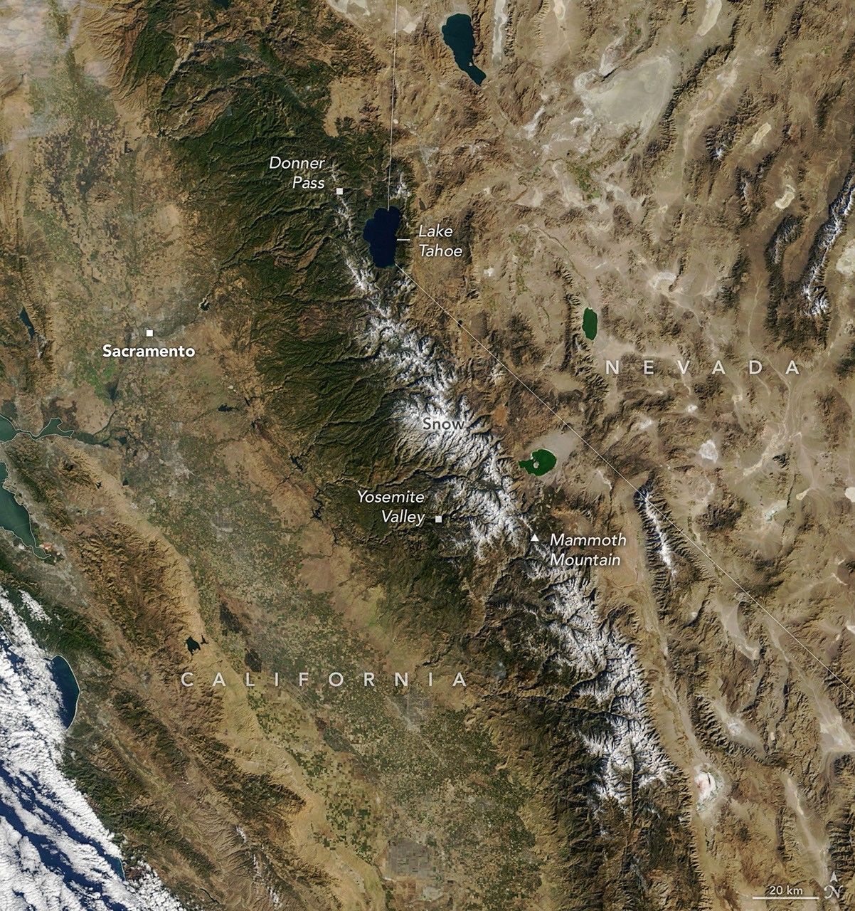
A widespread, early-season snowstorm swept across California in mid-November 2026, coating high-elevation peaks in white and signaling an opening shift toward winter across the Sierra Nevada. Regional observations and orbital tracking documented the storm's extensive reach, which delivered fresh snow cover across broad stretches of the mountain system. The early arrival of frozen precipitation marked a notable visual transition after weeks of dry autumn weather.
The storm system delivered one of the first widespread snow events of the 2026 winter season, blanketing prominent crests and alpine ridges across California. Satellite imagery and weather monitoring systems recorded significant surface whitening across the high country, confirming that colder air masses successfully supported frozen precipitation at altitude. For regional observers, the storm offered a visible confirmation that seasonal atmospheric patterns were beginning to spin up.
Mountain snowfall holds immense significance for California, serving as a frozen storage system that supplies a substantial share of the state's annual water needs. As winter progresses, snow that accumulates across the Sierra Nevada acts as a natural reservoir, gradually releasing moisture into rivers, reservoirs, and agricultural valleys during warmer spring and summer months. State hydrologists and resource planners consistently track these opening accumulations to gauge how early moisture conditions are developing.
Despite the encouraging start, climate scientists and weather forecasters emphasize that early-season snowstorms do not necessarily foreshadow a sustained wet winter. Western atmospheric dynamics are notorious for wide variability, often alternating between heavy precipitation cycles and extended periods of high pressure and dry weather. Whether mid-November snow represents the start of a prolonged stormy period or an isolated event remains dependent on upcoming weather patterns over the Pacific.
Earth observation tools, including remote sensing platforms monitored by NASA and meteorological partners, play a central role in measuring these evolving surface changes. Satellite instruments track snow extent, surface temperature, and reflectivity across rugged terrain that is otherwise difficult to survey continuously from the ground. These datasets help scientists examine how early snow cover interacts with regional soils and how much initial moisture is retained in alpine catchments.
The arrival of sub-freezing temperatures and mountain snow also brings immediate ecological benefits, particularly regarding wildfire suppression. After long months of summer heat and parched autumn winds, early cold moisture effectively dampens dry vegetation and curbs fire hazards across elevated wilderness zones. Watersheds that suffered stress during late summer receive a vital cooling effect as the mountain environment settles into early winter mode.
Beyond environmental implications, early mountain storms prompt operational shifts across transportation networks and mountain communities. Highway maintenance teams prepare plows and chain-control infrastructure along high-altitude passes, where sudden winter weather can quickly impact travel safety. At the same time, regional ski destinations and tourism operators welcome the snowfall as they finalize preparations for winter recreation and tourism activities.
As the mid-November storm clears, meteorologists and water managers are directing their attention toward prospective weather systems tracking across the northern Pacific Ocean. Ongoing updates from automated mountain sensors and ground surveys will measure how well the new snowpack holds against daytime solar warming. In the weeks ahead, scientists will monitor whether successive atmospheric systems arrive to reinforce the Sierra Nevada's snowpack and sustain California's early seasonal momentum.
Primary source: NASA Breaking News. Newzly rewrites and structures source reporting for clarity; verify critical details at the original.